Explore Our Latest News & Articles
The Great Bahama Bank encompasses a large swath of shallow water. It's along the periphery of this Great Bank that you will find the islands and ports of call. Just a hop across the Gulf Stream from Florida (but seemingly a world away), lies the group of 100 cays known collectively as "Bimini." A trip across the shallow waters of the Bank will then take you to the Berry Islands or Andros. Another deepwater passage across the Northeast Channel or the Tongue of the Ocean takes you to Nassau or the Exuma Cays farther south.
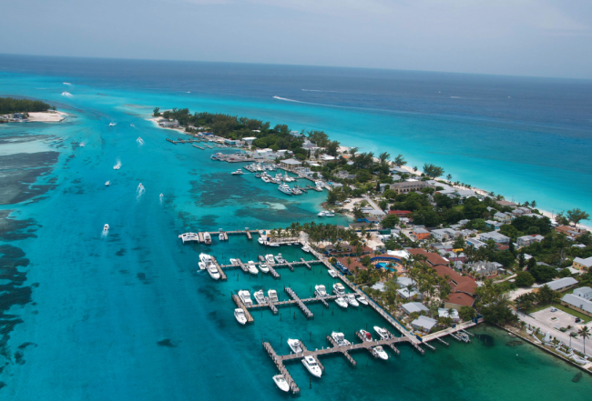
Bimini is a popular port of entry, but it's a destination in its own right with excellent sport fishing, a charming community of locals and a large resort complex. Alice Town, the main settlement, lies on North Bimini. The airport, Bimini Cove Resort (formerly Bimini Sands Marina) and a few restaurants lie on South Bimini just across a narrow channel. Cat Cay, to the south, hosts an exclusive marina and resort complex.
For many coming from the southern parts of Florida, Bimini is the main point of entry into The Islands of The Bahamas. The islands are a mere 50 nm east of the U.S. mainland and-even contending with the Gulf Stream's northerly push-most boats with any speed can comfortably leave for these islands at daybreak and reach them before sunset.
Whether you're seeking Bimini's rustic beauty or its lively shops and eateries, Bimini is a great place to visit or to spend a few nights before setting off across the Great Bahama Bank or waiting out a blow to return to the east coast.
For cruisers who are looking to make the most of suitable weather for eastbound travel, it is not necessary to stop in Bimini at all. If you opt to bypass the Bimini Islands, there are three main routes that pass Bimini and continue onto the Banks. Most cruisers choose to enter the banks north of North Rock or through the Gun Cay Cut. From there, continue on to the Northwest Channel, heading straight across the Great Bahama Bank. Although many slower vessels do anchor on the Great Bahama Bank, please keep in mind that there are more and more island freighters traveling at night from Florida to the Berry Islands and Nassau.
A convenient spot to find shelter when making passage to or from Great Harbour and Florida, especially if targeting landfall at Port Everglades or points north, is Backside Bimini North. This anchorage offers protection from southerly to westerly swells, particularly with a west wind. Depths of 2.4 meters/8 feet or more can be found within 213 meters/700 feet of the shoreline with a sandy bottom (although you may have to look around a bit amidst the turtle grass). This anchorage is not recommended in an east and/or north wind.
About North & South Bimini
North Bimini's main settlement, Alice Town, is a bustling hub of island activity. The main street (King's Hwy.) is a busy lane lined with homey restaurants, interesting shops and accommodating marinas. Everything is only a few minutes' walk from the Alice Town marinas. Long, sandy Radio Beach runs along the west side of Alice Town, looking out over the Straits of Florida. To the east are mangrove-covered islands with excellent bonefishing.
Separated by only 150 yards of water from its northern neighbor, South Bimini is an attractive, quieter alternative to busy Alice Town with easier access to the airport. On the north end near the ferry to Alice Town, there are a few homes, a snack bar, a liquor store and a grocery store. There is also a vehicle and small boat repair shop. The west coast has a stunning beach and this settlement is a treasured safe harbor for weather-weary cruisers. Taxis can bring your guests from the airport to the marina.
If you decide to spend some time here, don't miss touring the Bimini Biological Field Station where research is ongoing on lemon, bull, nurse and hammerhead sharks along with the tropical-marine ecosystem. Bimini Sharklab offers daily tours (242-347-4538). If you prefer hiking, spend a few hours on the 1-mile-long Bimini Nature Trail loop that begins and ends at the Bimini Cove Resort.
Navigation Notes
Refer to Explorer Chartbook Near Bahamas Chart BIM 1.
From the Bimini waypoint the channel lines up almost directly with the channel through the jetties into the Bimini Cove Resort on South Bimini. The buoys marking the channel and the channel itself are frequently moved or off station. The channel with the deepest water is just off the entrance to the resort. Conditions change continually here.
You will need to approach carefully and if you have a deep-draft vessel, make sure to contact your Bimini dockmaster for up-to-date advice. There is a shoaling sand bar extending south from the tip of North Bimini Island. Once over the tip of the bar and near the South Bimini beach, keep that sandbar to port and turn north to parallel the shoreline of South Bimini into the Alice Town harbor entrance. The channel is poorly marked and has migrated farther south due to shifting sands. Many of the marks are either off station or completely absent, making visual piloting more reliable. Use great caution in this area and during these approaches if wind or seas are running out of the southwest through west.

The old channel is farther south but also is not well marked; however, there is a lighted range that is useful for making the initial approach. In settled conditions both approaches are fine, but in conditions of poor visibility, the old channel (with its range) is easier to follow.
Older charts will show the more southerly approach channel hugging the long beach along the western shore of South Bimini. For boats with drafts of less than 1.5 meters/5 feet, this may still be a viable passage into Alice Town or an alternate route for Bimini Cove Resort . There is a range on this approach, and this is the recommended approach in low light or rough conditions. Turn north after you are safely past the sandbar keeping the rocks and shallows to port. You will be close to the beach but in deep water.
All vessels must exercise caution entering Bimini as ocean swells in the cuts can cause you to hit bottom. Read the water carefully. At any state of tide go cautiously on your final run in, watch your depth and be prepared to abort if necessary. With all the changes and dredging that have taken place here, contact one of the local marinas to get the latest information.
If the wind is from the west and any kind of significant sea is running, neither approach is usable. Don't attempt it! It is better to head offshore and take your lumps to continue to Gun Cay or North Cat Cay.
Other Suggestions
Conditions: Beware trying to enter Alice Town in southwest through northwest winds, particularly if the sea state is building. In moderate conditions you should be fine, but you are exposed broadside running along the beach on the west shore of South Bimini. You are very close to the beach as you do the final leg. Do not attempt it in unfavorable weather!
Approach Markers: The range markers for the southern channel off South Bimini and the approach markers can be hard to locate. If you don't spot them, run slowly up and down parallel to the beach. Stay in deep water until you have them fixed or call a local dockmaster for advice.
Chart Accuracy: The GPS may place you on the sand by Pigeon Cay by the time you are at the slip. Remember, the GPS may not be perfectly accurate and the chart position in the GPS may not be accurate either. As always, treat every GPS waypoint with caution and the charts with reservation. It is your eyes that are the most reliable; visual piloting applies for all inshore or shallow water navigation while in The Bahamas. Good light and polarized sunglasses are essential.
Clearing In: Tying up to the government dock to go to Customs and Immigration is no longer allowed. To clear in you must first go to the Customs office located just inside the entrance to the Bimini Big Game Club Resort and Marina. (Expect to pay a $50 landing fee or plan to stay a night at any of the marinas and just walk over.) From there, proceed north to the next block and the pink Bahamas Government Administration Offices where Immigration is located.
Inquire at a marina if they have blank immigration cards. Even though regulations state that only the captain should go ashore, we recommend the entire crew make the trip to the Immigration department. Once the immigration formalities are completed, only the Captain need go to the Customs office to complete the clearance procedures.
For more information on cruising North & South Bimini, including dockage and anchorages, purchase a Print Waterway Guide Bahamas Edition or a Bahamas Subscription.


- 4,000 Marinas
- Thousands of anchorages
- Updated Charts
- Mile-by-Mile Navigation
- Highlighted Alerts & Cautions
- Full-Color Aerial Photographs

The Waterway Guide App Makes it easy to leave reviews, use our explorer, and view waterway guide materials all on the go!