Explore Our Latest News & Articles
 Auto-routing (Route Planner in Aqua Map) is now available in Aqua Map! In the interest of safe routing, it incorporates numerous safety checks and utilizes the latest NOAA and USACE survey data in planning routes. Features include:
• Only the latest NOAA charts are used for planning, updated weekly from NOAA's chart database.
• Army Corps of Engineers (USACE) survey charts are used where available. This is especially valuable for the Intracoastal Waterway (ICW), for entrances to harbors, and for rivers along the Great Loop.
• Trusted tracks or routes can be used in shoaling areas where even the USACE surveys don't show the current water levels. For example, if part of your route lies on the Atlantic ICW, you can instruct Route Planner to follow the Bob423 track for the section of your route that lies on the ICW. Any trusted route or track can be used in this manner.
• The auto-routes can easily be manually edited to avoid hazards not evident on NOAA or USACE surveys.
• Hazards detected by Route Planner are highlighted for your examination.
• Starting and ending points can be chosen by name from a Points of Interest (POI) list or manually selected with a long press on the chart.
• The route distance, time, and fuel used are listed for the route.
Two examples follow: one in the Chesapeake Bay, as shown on the left, and one on the Atlantic ICW. First up, a route from the Annapolis, Maryland, Mooring Field to Safe Harbor Zahniser's Marina in Solomons Island, Maryland. The route took Aqua Map 3 seconds to plot the 22 waypoints required.
Although we often use the term auto-routing, the feature should be used as a route planner, the term used by Aqua Map to describe their new feature. Any route produced by an app must be checked to be sure safe water is followed.
The captain must check all routes produced automatically by any app through every waypoint to ensure safe navigation.
Do not depend upon any route generated automatically by any app or program to be error free. A charting program may not have the latest information on shoaling or other changes. Having access to USACE surveys in the case of Aqua Map is a great advantage, but even the latest USACE survey may not show shoaling found by recent boaters. An on-line source such as Waterway Guide Alerts and ICW Cruising Guide Facebook group is invaluable in keeping track of shoaling events.
Panning through the 23 waypoints is quicker than plotting them manually, especially for longer routes with many turns.
We will cover some adjustments to the route shown from Annapolis, MD to Solomons, MD.
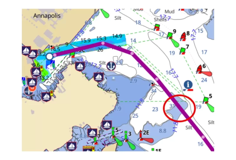
The red circle highlights an example of an adjustment. The passage has enough depth for a 5 ft draft boat, but a captain may want more leeway.
A tap on the route line at that point prompts if you want to add a new waypoint.
Tap on "Yes."
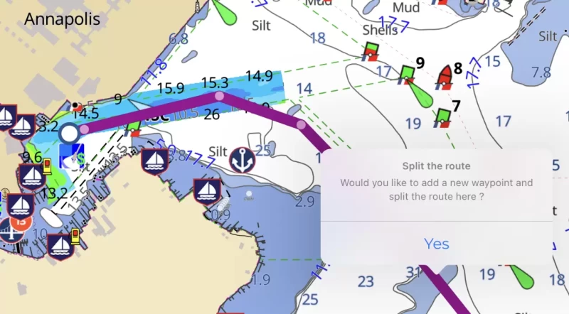
The new waypoint can be moved with your finger on an iPad to deeper water.
This procedure can be repeated as required along the route. In this case, two other adjustments were made farther along the track.

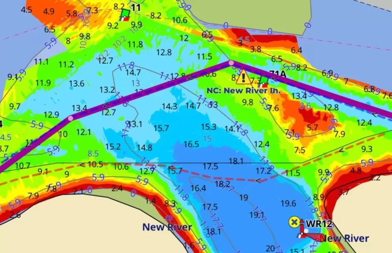
Let's look at auto-routing on the ICW. Due to the many shallow areas, you must use a "reference track" such as a Bob423 track set to "High" priority and safety checks to "Off." The route so generated, as always must be checked to ensure a safe passage, and in some cases, with a tide. The route we'll examine is from Homer Smith in Beaufort, NC to Harbour Village Marina. It's 57.6 NM long and takes 7:53 hours at our cruising speed of 7.3 kts, using 10 gallons of diesel. I have the Bob423 tracks visible (blue dotted line) and the side trips (red dotted lines). Auto-routing took advantage of the back door exit by following the Bob423 side trip track.
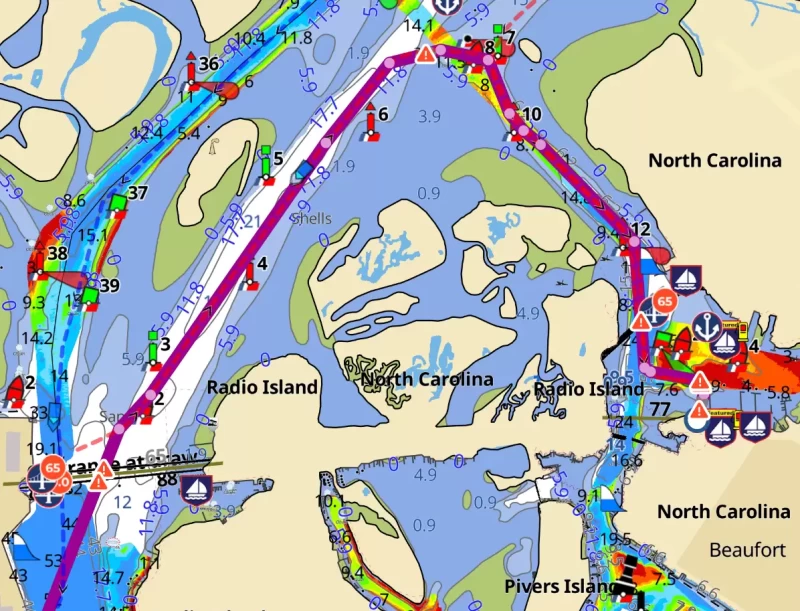
The "back door" exit from Homer Smith was followed pretty well. The jog by 5A was followed faithfully.

Auto-routing followed the reference track through New River.
Route Planner provides a quick way to calculate distances on the ICW that follow known paths without a concern about the route suddenly going out an inlet that you did not intend to take.
Editing a route that's close to where you want to go is much faster than creating one from scratch. The settings affecting auto-routing used in the previous examples are detailed below. They can be accessed with a tap on the Settings icon at the lower right of the Aqua Map screen.
Boat measurements in My Boat:
- Draft. An accurate keel depth is vital. If you want to add a safety factor, don't do it here. Put in the actual draft of your boat. There's an option in Route Planner to add a safety factor for auto-routing.
- Height of mast. Use the actual mast height without a safety factor.
- Average speed. The time and fuel required for the passage on the route are calculated based on this number.
Options in Route Planner:
- Resolution: Standard/High. Choose "High." The ICW has many narrow passages that benefit from "High" resolution in forming a route, but require more CPU power. However, the Chesapeake route example only took 3 seconds to compute on my iPad Pro 12.9 with an M1 chip on High.
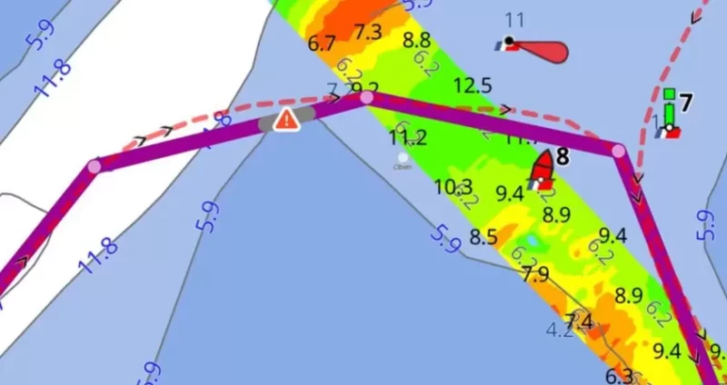
- Safety Checks: Weak/Strong. Choose "Weak." The route will need to be carefully checked anyway before use. No route from any auto-routing software should be blindly followed. Shallow water and low heights typical of the ICW will still be highlighted on the route for your review. In deeper waters such as Long Island Sound and Maine, Safety Checks being on can be helpful.
- Use visible Tracks & Routes: On/Off. There are sections of the ICW that are very narrow with many sharp turns. A trusted track is recommended in those areas, since it will be more up-to-date with shoaling levels than a NOAA chart, and even for many USACE surveys. To avoid confusion in auto-routing, have only one trusted track visible at a time in the area you're routing through.
▪ Skip tracks safety checks: On/Off. Turn to ON since you're going to manually check the track anyway. The safety checks will still be visible on the track.
▪ Tracks/Routes priority: Standard/High. Set to "High" to enforce following a trusted track.
- Draft Setting, additional margin: A number added to the My Boat draft. Set to zero since the track will be manually checked anyway, and the route formed includes warnings for shallow water. The auto-routing feature uses MLLW as the chart depth and so does not account for tide. With the 8 foot tides in Georgia, the channels allow deep draft vessels to pass when they cannot at MLLW. Checking a route through s shallow area and with the knowledge of the time of passage and the tide is a must.
- Clearance setting, additional margin: A number added to the My Boat Height. As for the draft, set to zero since the route will be manually checked. Any height exposures will still show up in the route as a warning.
The examples used the settings described above.However, there are some limitations. There are overhead cables along the ICW that are not labeled correctly by NOAA as to their height above the ICW. This plays havoc with the auto-routing algorithm, causing a route to exit an inlet and then re-enter farther down, away from the offending overhead cable. Eventually, NOAA will correct the data, but until then, the workaround is to use a reference track such as a Bob423 track, which overrides the bad height data and allows a route to be formed.
There are more capabilities than covered in this article. See the video tutorial by Aqua Map for more examples of the use of Route Planner. For a guidebook on how to safely navigate all ICW shoaling areas, see 2025 ICW Cruising Guide by Bob423 available from Amazon and Waterway Guide. Additional guides are listed at Bob423 Publications.


- 4,000 Marinas
- Thousands of anchorages
- Updated Charts
- Mile-by-Mile Navigation
- Highlighted Alerts & Cautions
- Full-Color Aerial Photographs

The Waterway Guide App Makes it easy to leave reviews, use our explorer, and view waterway guide materials all on the go!