Explore Our Latest News & Articles
For vessels transiting some areas of the AICW the threat of running aground or bumping the bottom is an ongoing problem. Dredging, timing passage at high tides, or finding alternate routes are often the only solutions. Proper management of the intracoastal waterways is an important effort of the U.S. Army Corps of Engineers (USACE) and other agencies dedicated to maintaining the waterways for all maritime interests.
Citizen scientists and interested groups also contribute to the ongoing evaluation and knowledge associated with the condition of the AICW. The Atlantic Intracoastal Waterway Association (AIWA) is dedicated to securing funding and support for the maintenance of AICW. AIWA engages multiple users and funding sources in its ongoing work of ensuring that the waterway is navigable and safe.
Waterway Guide Media contributing editor Bob Sherer (Bob423) has devoted extraordinary time, effort, and multiple resources toward the goal of reporting on the conditions of many of the problem areas of the AICW. His work over the years has resulted in increased collaboration between multiple interests toward the goals of safety and awareness.
In this latest assessment of two critical stretches of the AICW, Bob423 offers some detailed insights into two areas that have experienced rapid shoaling over the past two months. Boaters are already using detours as shown in the charts, but even the detours are threatened. Dredging is urgently needed for both areas before the fall migration of recreational and pleasure boats.
The Two Problem Areas
- Buttermilk Sound at the intersection of the South Altamaha River and the AICW, MM 662 by R218 from 7.0 MLLW to 4.9 MLLW
- Jupiter Inlet at MM 1004 by R2 from 8.8 MLLW to 6.2 MLLW
There are other shallow areas on the AICW, but these two have shown the most recent changes. The sources of the depth readings on the chart are from mariners with sounders calibrated with a lead line.
The depths are fed over NMEA to a WiFi Gateway, which in turn broadcasts the depths to an iPad running Aqua Map, which inserts the depth readings into a recorded track. Each track point has a Lat/Long, date, time, and depth reading, which allows the depths to be converted to MLLW using a nearby tide station. Bob423 Surveyors also upload all tracks to NOAA's Bathymetry database for access using the NOAA Bathymetry Viewer. However, the files are not in GPX format when downloaded, but a conversion program is available at Bob423 Crowd Source Bathymetry with instructions for easy use. Waterway Guide publishes the details of the surveys as seen in the links below.
Buttermilk Sound at MM 662, last USACE survey: 10/20/2022

Note: The thin black line in the channel is the NOAA recommended track. It was good on 10/20/2022, but would now lead you into a shoal, as you can see on the next chart.
Buttermilk Sound at 6/22/2025 based on Bob423 Surveyor depth readings

The shoal has been shaded in red to show the area of 5 MLLW or less. Otherwise, the depth readings and contour colors on the chart are from 10/20/2022 and do not reflect the depths as of 6/22/2025. You can see that the NOAA channel is completely shoaled to 4 MLLW or less, and a detour around the shoal is required. For the present, there's still a way around the shoal, but as it grows, the detour will not work much longer. Most recently, two boats grounded on 7/5/2025 with a draft of 5.2 feet and a 1.0 ft tide following the previous Bob423 track, which was outside the channel but not far enough. The Bob423 track has since been moved to the new location, as shown on the chart by the blue line.
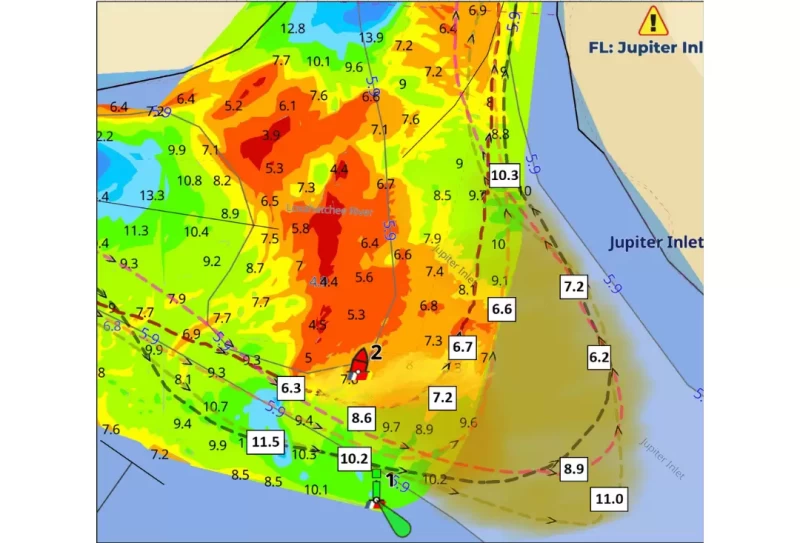
Jupiter Inlet ICW crossing at MM 1004 by R2, last USACE survey: 1/29/2025
For the AICW crossing at the Jupiter Inlet, five tracks were analyzed from March and April of 2025: two Bob423 Surveyors tracks and three tracks from NOAA's Crowdsourced Bathymetry (CSB) database. The Bob423 Surveyor tracks were already calibrated to read from the water surface to channel bottom, so they only needed a tide correction for MLLW. The three CSB tracks were adjusted to read surface water depth against the Bob423 Surveyor tracks at a calibration area (not shown on the chart) where they crossed in a non-shoaling area. The three CSB tracks were adjusted for tide. The tracks were loaded into Aqua Map, which displayed a depth graph used to find the least depth and its location on the track.
The chart shows the depths in feet found at MLLW at various points in a transit of the Jupiter Inlet. The shoal by R2 is advancing farther southeast with readings of 6.6, 7.2, and 6.2 MLLW at the eastern turn. The channel between R2 and the east shore is shoaling. The area of increased shoal water has been shaded to indicate the extent of the shoal's growth.
For a guidebook on how to safely navigate all ICW shoaling areas, see 2025 ICW Cruising Guide by Bob423 available from Amazon and Waterway Guide. Additional guides are listed at Bob423 Publications.
See How Surveys are Conducted by Bob423 Contributors.
Additional Details on Survey Workflow


- 4,000 Marinas
- Thousands of anchorages
- Updated Charts
- Mile-by-Mile Navigation
- Highlighted Alerts & Cautions
- Full-Color Aerial Photographs

The Waterway Guide App Makes it easy to leave reviews, use our explorer, and view waterway guide materials all on the go!