Explore Our Latest News & Articles
Unlike coastal regions where lunar tides dominate, water levels in North Carolina's Albemarle and Pamlico Sounds are primarily wind-driven. Traditional tide tables offer limited guidance here. This article from cruiser Malcolm Rubel explains why, and what, boaters need to know to navigate safely in these variable conditions.
In northeastern North Carolina, water levels don't pay much attention to the moon. Even where there are published tide tables, they don't behave normally and there are implications for boaters. In both the Albemarle and Pamlico Sounds, as well as the Neuse River, the wind is a key factor, and understanding how this works is important to safe boating.
Looking at the map you can see this expanse of waters is sheltered from the Atlantic by the Outer Banks. Closer inspection shows that there are only a few narrow inlets from Beaufort to the Virginia line where the Atlantic lunar tide flows in and out. Once you get away from the actual inlet, there is not enough water to make a meaningful difference in the local water level so, for all intents and purposes, there is no lunar tide for the sounds. The published tide chart for Oriental shows this.

According to NOAA, the mean tidal range for Oriental is about four inches. However, the actual water level differences tell a different story, as shown by a two-week track from NOAA's "Neuse River Water Levels at Oriental" gauge.
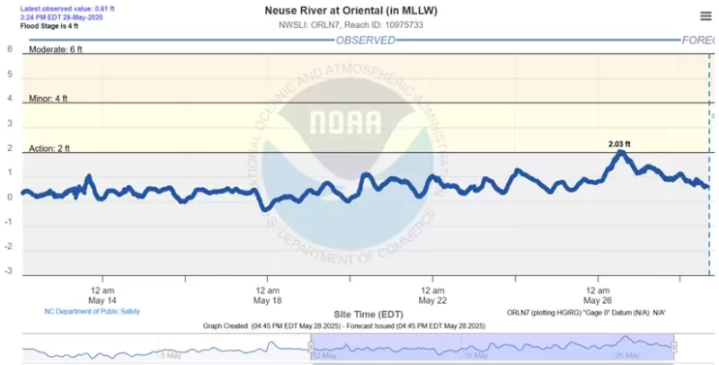
During this two week period ,the water levels range from -0.5' to +2.03' for a range of better than 2.5 feet. Notice also that the changes in levels are not timed to the gravitational forces; they are associated with the wind. Direction, Strength, and Duration are the keys. When the wind blows from the north and east, water is blown out of the Albemarle and down into the Pamlico and Neuse. While south and west winds blow the southern waters all the way up to Elizabeth City, Coinjock and even as far north as the Great Bridge Lock. Strong winds, lasting more than a day, will magnify the changes. On May 26th there were 15 knot winds from the NE and, in a twelve hour period, water levels in Oriental went up 1.5 feet. When the wind stopped blowing, the water level started to fall back towards zero. Luckily, there was nobody tied up at the town dinghy dock while this was happening.

These are normal occurrences and affect not only water depth but also bridge height calculations. There are two bridges in this area for which this is really important: the Wilkerson (mm 125.9) and the Hobucken (mm 157.2) Bridges. The Wilkerson Bridge is listed at 64 feet and the Hobucken Bridge, while listed as 65 feet, has several reports indicating this might not be true. To make matters worse, the Hobucken Bridge does not have clearance boards. You will need to get water level data if you are the captain of a tall masted sailing vessel. Fortunately there are NOAA water level stations in Hobucken and Belhaven that provide data in relation to zero which, for both stations, is MLLW. For other areas there is a list of stations available at https://www.weather.gov/mhx/LocalFloodGauges. Hopefully, masts (or at least antennas) will be saved. Also, if you are tied to a fixed dock, make sure to account for the possibility of more than a six inch change in water level.
 About Capt. Mac Rubel & Deb Boswell
For the past seven years Deb and Mac have cruised the east coast from Houston to Florida to Maine and back on Janthina, their DeFever 48 trawler, logging almost 20,000 miles and almost 1,000 days on the boat. They crossed their wake on the Loop in January 2022 and are well into their second circle. For 2025 their plans are to spend four months in the Albemarle and the Chesapeake, exploring new places and revisiting several old favorites. Deb is a marine biologist, the photographer, and manages the boat. Mac is a retired Master Maine Fishing Guide and was a software applications development consultant on the side. He drives the boat and is in charge of fixing things. Both Deb and Mac are fascinated by the history that they travel through and, in addition to reviews, they will be spending time developing submissions for Waterway Guide along the way.


- 4,000 Marinas
- Thousands of anchorages
- Updated Charts
- Mile-by-Mile Navigation
- Highlighted Alerts & Cautions
- Full-Color Aerial Photographs

The Waterway Guide App Makes it easy to leave reviews, use our explorer, and view waterway guide materials all on the go!