Explore Our Latest News & Articles

Today is the big day. You're headed through the famous shallows around McClellanville in the Isle of Palms, South Carolina. It's a bright and sunny day, perhaps a little windy but that's no big concern in the protected waters of the Intracoastal Waterway. You've done your homework and read the NOAA tide tables, including one from yesterday that was corrected to 5.47 feet mean lower low water (MLLW). You're going through on a falling tide a little before low tide with a predicted variance of .65 feet. You don't foresee any problem with a 4-foot keel. It will be tight but you should be okay. As you progress, the water depth seems a little less than expected so you slow down a bit to be sure to stay in the channel. Unfortunately, because you're going slower, the tide is dropping even more. Then you hit bottom and you're stuck! What happened?
I'm sure the first chorus from shore will be, "Hey dummy...never challenge McClellanville at low tide!" But we're interested in just the facts. Let's take a look at Feb 7, the day of this adventure.
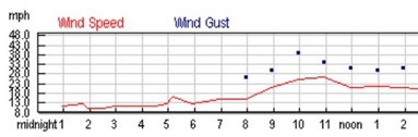
This first thing you notice is the increase in wind speed with gusts up to 39 mph (34 kts). Although the chart doesn't show it, the direction is out of the northwest. It's the ideal direction to push water out of Charleston Bay and the associated bodies of water nearby. Next, let's look at the tide level vs. predicted (per tide tables).

Now you can see the problem. The actual water level was following the predicted level until the northwest wind started blowing. At low tide and approaching low tide, there was 1.688 feet lower water verified, which was over 1 foot more than the 0.625 predicted for Feb 9, 2017 at noon. Look at how quickly the northwest wind pushed the water out! Now it's true that the tide station measuring actual vs. predicted is located in Charleston, about 30 miles southwest. But my experience has been that it's a pretty good predictor of what's happening in the Isle of Palms too.
What about those times when there's more water depth than predicted? What causes that? Let's look at a wind report from 11/11/2017.

The wind was blowing out of the northeast (and had been for several days) with gusts to 26 mph (23 kts) on 11/11/2017. Any wind with an easterly component will tend to push water against the coast with the result shown below at the Charleston tide station for the same day. If you had transited the Isle of Palms that day, you would have enjoyed an extra foot of water above the predicted tide level. I like to see charts like the one below when I transit McClellanville!

So, the moral of the story is to pay attention to the wind in your plans and take advantage of those tide stations that give the actual tide vs. predicted tide. Of course, an abundance of rain can also raise the water level, but the same tide stations will also give you an indication of that effect. By now you should appreciate how two captains can go through the same stretch of shallow water and see a 2-foot difference in depths even when corrected to MLLW! There was more than 2 feet of difference in the two charts above. Take advantage of the data available on the web and understand the variables of your environments. The ICW is forgiving but 5 to 6 hours heeled over aground is not the best way to enjoy your time aboard.


- 4,000 Marinas
- Thousands of anchorages
- Updated Charts
- Mile-by-Mile Navigation
- Highlighted Alerts & Cautions
- Full-Color Aerial Photographs

The Waterway Guide App Makes it easy to leave reviews, use our explorer, and view waterway guide materials all on the go!